
A field-engagement platform for reaching constituents where they are: search the base, see who's nearby on a map, and build an efficient visit route, all from one system a non-technical team can actually run.
The Challenge
Organizations that engage constituents in the field, canvassing, outreach, casework, keep hitting the same wall: their people, their turf, and their data all live in different places. Answering a simple question like "who should we visit near this address?" meant database queries, spreadsheet cross-referencing, and a paper map. There was no shared system for a team to actually work from together.
Our Approach
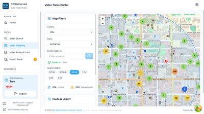
We built a constituent engagement platform with mapping at its center. A team searches the constituent base, sees everyone within a radius of any address plotted instantly on an interactive map, filters by the criteria that matter, and generates an optimized route to go visit them. Role-based accounts keep coordinators, team leads, and volunteers working from the same data at the right level of access, and a multi-source geocoding pipeline keeps address lookups fast and reliable.
Key Features
- Constituent Search: Query the full base with multi-criteria filtering, no database skills required
- Radius Mapping: See everyone within a chosen distance of any address, plotted the moment you ask
- Route Optimization: Build an efficient visit order automatically; click any point to re-sequence from there
- Role-Based Access: Coordinators, team leads, and volunteers share one system with appropriate permissions
- Field-Ready Outputs: Interactive map, sortable table, CSV export, and a print-optimized view
- Field planning drops from a multi-step chore to a few clicks
- Non-technical volunteers run their own lists and routes
- One shared platform replaces scattered queries, spreadsheets, and paper maps
The Results
Technologies Used
Leaflet.js, PHP, MySQL with spatial indexing, role-based access control, public geocoding APIs, Docker